Compass - Digital Compass 2026
- 4.5
- Rating
- 500.00K
- Installs
- Free
- Price
 Analysis by App-foxy
I tend to keep a compass app for the moments when a map feels like too much information. Compass - Digital Compass 2026 takes that focused approach: it is a free navigation app from Firehawk that puts directional guidance first, while also bringing altitude and sun timing into the same view. After using it as a quick orientation tool, I found its main appeal is not replacing a full mapping service. It is reducing a simple question—“Which way am I facing?”—to something I can answer immediately.
That difference matters. A mapping app is excellent when I need a route, traffic information, addresses, or turn-by-turn instructions. A digital compass is better when I am standing at a trail junction, checking the direction of a balcony, lining up a camera shot, or trying to understand where the sun will appear later. This app stays close to that second kind of task. Its design is simple enough for an occasional user, but the extra altitude and sunrise and sunset information give it more practical value than a bare directional dial.
Why the compass is the real center of the experience
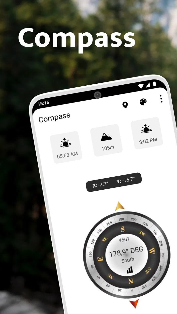
The most important capability here is the live directional display. Instead of making me search through a map or interpret a route, the app gives me a direct reading of orientation. That makes it useful in situations where I already know where I want to go but need a reliable sense of direction before moving.
You May Also Like

 Blood Strike: 2.5 Anniversary
Blood Strike’s Loadouts Turn Every Drop Into a Tactical Gamble
A close look at Blood Strike’s custom loadouts: how fast access to signature weapons reshapes its battle royale rhythm, rewards preparation, and narrows the gap between fights.

 Pandora - Music & Podcasts
Pandora’s Music Is Easy to Start, but Harder to Recover
Pandora’s strength is its low-effort path from a seed to a station. Its weak spot is how much confidence it asks you to place in connection, setup, and quiet recovery.

 8 Ball Pool
 Is Built on Rivalries, Rematches, and Routine
A close look at the rivalries, rematches, shared routines, and unanswered safety questions that turn a quick pool match into a persistent mobile community.

 Samsung Music
’s Quiet Strength Is Playing What You Already Own
Its reach comes less from spectacle than from dependable access to a personal library. That simplicity is both the app’s strongest retention engine and its ceiling.

 AccuWeather: Weather Radar
AccuWeather Review: A Quick, Clear Forecast for Everyday Decisions
For everyday plans, the best forecast is the one you can understand quickly. AccuWeather makes rain timing, radar, and local conditions easy to act on, with a few trade-offs.

 Hill Climb Racing
Why Hill Climb Racing Still Turns Crashes Into One More Run
A tiny car, a bumpy hill and one more upgrade: Hill Climb Racing keeps resurfacing because its simple chaos makes every near-miss feel personal.
More From Our News Desk



I especially like this approach for outdoor orientation. If I pause on a path and want to identify the general direction of a viewpoint, the compass answers that question without forcing me to create a destination. It also helps when a paper map, sign, or set of written instructions refers to north, south, east, or west. I can compare the direction in front of me with the direction described on the map, then continue with a clearer mental picture of the area.
The app also benefits from keeping its supporting information relevant to orientation. Altitude can add context during a hike or a drive through changing terrain, while sunrise and sunset times are useful when I am deciding how much daylight remains. These details do not turn the app into a complete outdoor planning suite, but they make the compass more useful during a real outing.
One subtle strength is that the app encourages me to think in terms of direction rather than route instructions. That sounds basic, but it changes how I use it. When a navigation service tells me to follow a series of turns, I am dependent on its route. With a compass, I can look at the landscape, signs, and landmarks myself. For short, familiar journeys, that can feel less distracting and more natural.
There is also a practical benefit for people who do not want a crowded interface. Many navigation tools combine maps, saved places, traffic layers, businesses, transit, and notifications. Those features are valuable, but they can obscure a simple directional check. Here, the central purpose is easier to understand from the first launch: open the app, read the direction, and use the additional environmental information when it helps.
How I use the directional reading in practice
My first habit with any compass app is to avoid treating the initial reading as unquestionable. A phone’s internal sensors can be influenced by nearby metal objects, electronic equipment, or the way the device is held. I get a more useful result when I hold the phone steadily, keep it away from obvious sources of interference, and give the display a moment to settle before making a decision.
That is not a flaw unique to this app; it is part of using a phone as a compass. Still, it is important because a clean design can make a reading look more authoritative than it really is. I would not use a quick glance at the screen as the only basis for a safety-critical decision in unfamiliar terrain. For ordinary orientation, however, the app is convenient and direct.
A good workflow is to use the compass before starting rather than constantly staring at it while walking. I can establish the direction of a trail, road, or landmark, put the phone away, and use visible features to stay oriented. This saves battery and keeps my attention on the surroundings. If I become uncertain, I can check again instead of turning the entire walk into a screen-based activity.
The altitude display is most useful as a reference point rather than a precision instrument for technical planning. I might compare the reading at the beginning and end of a walk, or use it to understand whether a route is climbing as much as expected. I would not treat a phone-based reading as a substitute for specialized equipment when exact elevation matters.
Sunrise and sunset information fits naturally into the same workflow. Before leaving for a walk, I can check the expected daylight window and then use the compass to understand the direction of the morning or evening light. That combination is particularly handy for photography, sightseeing, and choosing a place to sit outdoors. It turns the app from a single-purpose directional tool into a compact orientation reference.
One tip I found useful is to separate two questions: “What direction am I facing?” and “Where should I go?” The compass answers the first one, but it does not automatically solve the second. If I need a precise destination or a safe route, I switch to a map service. If I only need to identify direction or relate the landscape to the sun, this app is usually the more efficient choice.
A realistic everyday situation where it makes sense
Imagine arriving at a large park for an early walk. The entrance sign shows several paths, but the map board is difficult to read and the landmarks are unfamiliar. I can open this app, check which way I am facing, and compare that direction with the printed trail map. If I know I want to walk toward a viewpoint on the eastern side, I have an immediate reference before choosing a path.
Later, I may want to stop for a photograph. The sunset information helps me judge whether the light is likely to be useful, while the compass helps me understand which side of the park will face the setting sun. I still need to choose a safe and accessible location myself, but the app gives me the orientation information needed to make that decision without repeatedly opening a full navigation service.
Another realistic use is finding a building entrance in a large complex. A map may show the building, but not always make the final approach intuitive. If a friend tells me to meet at the entrance on the north side, a compass can help me walk around the structure with a clearer sense of direction. It is a small task, yet this is where a focused tool can be faster than a feature-heavy alternative.
For travel, the app can help me connect a place to its surroundings. I can use it from a hotel balcony to understand which direction the coastline, mountains, or old town lies in, then use a map app when I am ready to plan the actual route. That division of labor feels sensible: this app supports awareness, while a mapping service handles logistics.
Where the simple design helps—and where it stops
Firehawk’s app is strongest when I want a quick, uncluttered answer. The store summary emphasizes a precise and simple compass with a polished design, and that description matches the role it plays in my routine. I do not need to build a route, create an account, or learn a complicated planning system just to check orientation. The low barrier is one reason I can imagine recommending it to a friend who wants a straightforward compass rather than a complete navigation platform.
That simplicity also creates the main trade-off. I should not expect turn-by-turn navigation, detailed cartography, traffic information, route recording, or the broader planning tools normally associated with map applications. Someone choosing a navigation app for commuting, delivery work, cycling directions, or unfamiliar city travel will probably get more value from a full mapping product.
The app is also not a replacement for a dedicated hiking navigation setup. A compass reading alone does not show terrain, hazards, trail closures, water sources, or the safest route. Even with altitude and sun timing available, I still need appropriate preparation for remote areas. I would use this as one small part of an outdoor kit, not as my only source of guidance.
Sensor behavior is another consideration. If the phone’s compass is poorly calibrated or affected by the surroundings, the reading may drift or point inaccurately. I recommend checking the phone’s sensor behavior in an open area before relying on it during a trip. It is also wise to compare the direction with obvious landmarks when possible. That extra caution takes only a few seconds and makes the app more dependable in practice.
The app is free to install, which makes it easy to try for occasional needs. It is marked suitable for Everyone, and it supports phones running Android starting with version 5.0. The current version is 1.3.2. There are in-app purchases ranging from $0.99 to $99.99 per item, so I would review any purchase screen carefully before confirming anything. For a person who only needs basic orientation, the free starting point is appealing, but the presence of optional purchases means I would not assume every part of the experience is included without checking the screen in front of me.
Its public reception suggests that many people find the concept useful: the app holds a 4.5 average from around 4.1 thousand ratings and has passed 500 thousand installs. I see those figures as signs of an established audience, not proof that every phone will produce identical sensor results. The actual experience still depends on the handset, its sensors, and how the app is used.
Who will get the most from it
I think this app suits casual hikers, travelers, photographers, campers, students learning basic map orientation, and anyone who occasionally needs a compass without wanting a large navigation system. It is also a sensible utility for a household phone because the use cases are easy to understand: checking direction, looking at altitude, or estimating the timing of daylight.
It can be especially helpful for people who prefer visual simplicity. A friend who finds full map apps overwhelming may appreciate having one screen devoted to orientation. The app also works well for short checks where opening a map would feel excessive. That includes choosing a sun-facing seat, understanding the direction of a view, or matching a written instruction to the surrounding landscape.
I would be more cautious about recommending it to professional guides, surveyors, serious backcountry travelers, or anyone who needs documented precision. Those users may need specialized instruments, offline maps, route data, or safety features that this focused compass experience does not aim to provide. Likewise, commuters and drivers should choose a navigation service designed around routes rather than direction alone.
People who rarely leave familiar surroundings may not need a dedicated compass at all. A standard map app can cover many occasional orientation questions, especially if the user already has it open for directions. The reason to choose this one is convenience and concentration, not a promise that it will do more than a full navigation platform.
My final view after using it as a focused navigation tool
Compass - Digital Compass 2026 succeeds because it understands the value of a narrow purpose. Its directional display is the feature that matters, and the altitude plus sunrise and sunset information gives that feature more context without changing the app into something complicated. I found it most useful when I needed orientation quickly, then wanted to return my attention to the real world.
The right expectation is important. This is not the app I would choose to plan a multi-stop journey, navigate a city by car, or prepare for demanding wilderness travel. I would choose a map service or dedicated outdoor equipment for those tasks. But when the question is simply which way I am facing, where the daylight is coming from, or how my surroundings relate to elevation, this app is easier to reach for.
Firehawk has made a practical free utility for users who value a clean directional reference. I would recommend trying it if you want a simple compass for walks, trips, photography, or everyday orientation. My strongest advice is to hold the phone steadily, check the reading against the environment, and treat the extra information as helpful context rather than a substitute for proper navigation. Used that way, this is a focused tool that earns its place beside—not instead of—a full map app.
FAQs for Compass - Digital Compass 2026
01What is Compass - Digital Compass 2026 used for?
Compass - Digital Compass 2026 is designed to turn your Android or iOS device into a digital compass for identifying directions such as north, south, east, and west. It can be useful for hiking, traveling, camping, navigation, outdoor activities, or simply learning your orientation. Its accuracy depends on your phone’s sensors, calibration, and surrounding environmental conditions.
02Does Compass - Digital Compass 2026 require an internet connection?
In most situations, a digital compass can determine direction without mobile data or Wi-Fi because it uses the device’s built-in magnetic sensor. This makes Compass - Digital Compass 2026 convenient for outdoor trips where connectivity may be limited. However, certain optional features, advertisements, location-based tools, or map-related functions could require internet access, depending on the version installed.
03How do I calibrate Compass - Digital Compass 2026 correctly?
If the compass pointer appears unstable or points in the wrong direction, calibration may be necessary. Move the phone slowly in a figure-eight motion and follow any instructions shown inside the app. Keep the device away from magnets, speakers, metal objects, wireless charging pads, and vehicles while calibrating. Recalibration may also be needed after changing locations or using a protective case with magnetic components.
04Can Compass - Digital Compass 2026 work on every phone?
The application may install on many modern Android and iOS devices, but reliable compass functionality requires a built-in magnetometer or magnetic sensor. Some budget phones, tablets, or older devices do not include this hardware, so the app may display a warning or provide inaccurate readings. Before downloading, check the store compatibility information and confirm that your device supports compass sensors.
05Is Compass - Digital Compass 2026 accurate enough for navigation?
Compass - Digital Compass 2026 can be helpful for general orientation, outdoor activities, and basic direction finding, but it should not replace professional navigation equipment. Accuracy can be affected by nearby metal, electronic devices, magnetic interference, poor calibration, or sensor limitations. For hiking, boating, emergencies, or unfamiliar terrain, use the app together with a physical compass, maps, GPS, and other dependable navigation methods.
Pros
- Quickly shows heading
- latitude
- longitude
- and altitude.
- Simple interface is easy for beginners to understand.
- Useful for hiking
- travel
- camping
- and basic navigation.
- Works well as a lightweight alternative to a physical compass.
- Large compass display remains readable at a glance.
Cons
- Accuracy depends on your phone’s magnetometer and calibration.
- Nearby metal objects can cause incorrect or unstable readings.
- Some features may require location permissions to work properly.
- Readings can be less reliable indoors or near electronic devices.
- Advertising may interrupt the experience in the free version.

Compass - Digital Compass 2026
Gallery